Pipeline 3D Mapping


Our Services
CONTACT US
Our team is ready to assist with inspection, testing, cleaning, excavation, and rehabilitation needs.
Check On Our Social Media

Pipeline 3D Mapping
Accurate spatial data for better planning and long-term asset management
Understanding where a pipeline is located is just as important as understanding its condition. Pipeline 3D mapping captures precise spatial data that shows alignment, depth, slope, and orientation of underground infrastructure, creating a clear digital record that can be used for planning, design, and future maintenance.
At Acme Utilities Inspection Services, pipeline 3D mapping transforms inspection data into reliable, usable information. Instead of relying on outdated drawings or assumptions, owners and engineers gain an accurate representation of underground assets that supports smarter decisions and reduces uncertainty on future projects.
At Acme Utilities Inspection Services, our manhole and structure rehabilitation services focus on restoring structural integrity, sealing out water, and protecting assets from further deterioration. The goal is not just to repair damage, but to extend service life and reduce the need for full replacement.
Why Pipeline 3D Mapping Matters
Inaccurate or incomplete pipeline records often lead to design conflicts, construction delays, and unexpected costs. 3D mapping provides clarity that traditional inspection alone cannot.
Pipeline 3D mapping helps:
- Improve accuracy of asset records
- Support engineering design and rehabilitation planning
- Reduce risk during future construction or excavation
- Eliminate guesswork caused by outdated or incomplete drawings
- Provide long-term value through reliable digital documentation
OUR SERVICES
Pipeline 3D Mapping Solutions
Accurate mapping and documentation services that provide reliable underground data for planning, design, and asset management.
GIS Pipeline Mapping
GIS Pipeline Mapping
Digital mapping showing the precise location and layout of underground pipelines.
3D Pipeline Modeling
3D Pipeline Modeling
Three-dimensional visualization of pipeline alignment, depth, and geometry.
As-Built Pipeline Documentation
As-Built Pipeline Documentation
Accurate records of final pipeline installation for long-term reference.
Utility Locating Support
Utility Locating Support
Mapping support to identify underground utilities and reduce damage risk.
Asset Inventory Mapping
Asset Inventory Mapping
Organization and tracking of pipeline assets for maintenance planning.
Infrastructure Condition Mapping
Infrastructure Condition Mapping
Integration of inspection data to display pipeline condition system-wide.
Spatial Data Collection
Spatial Data Collection
Capture of accurate underground data for engineering use.
System Layout Verification
System Layout Verification
Confirmation that installed pipelines match approved design plans.
Digital Record Integration
Digital Record Integration
Preparation of mapping data for GIS and asset management systems.
Our Latest Projects
Pipeline Mapping Visualization
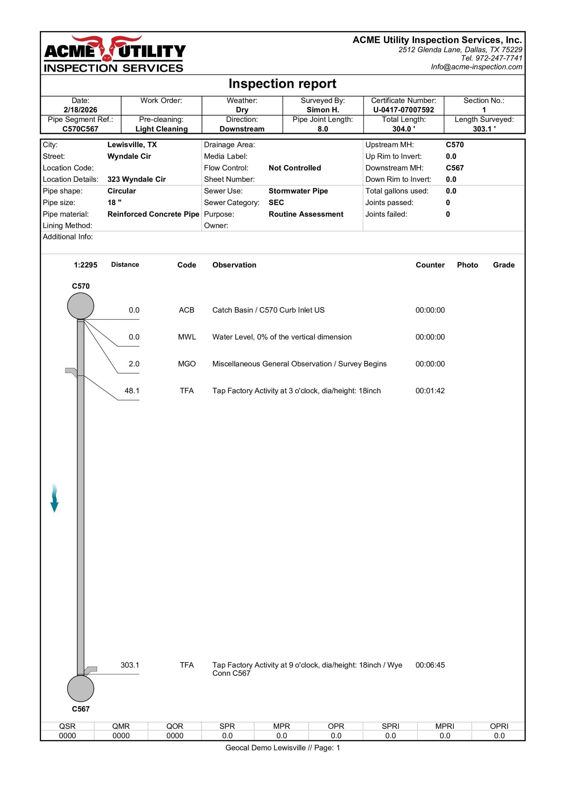
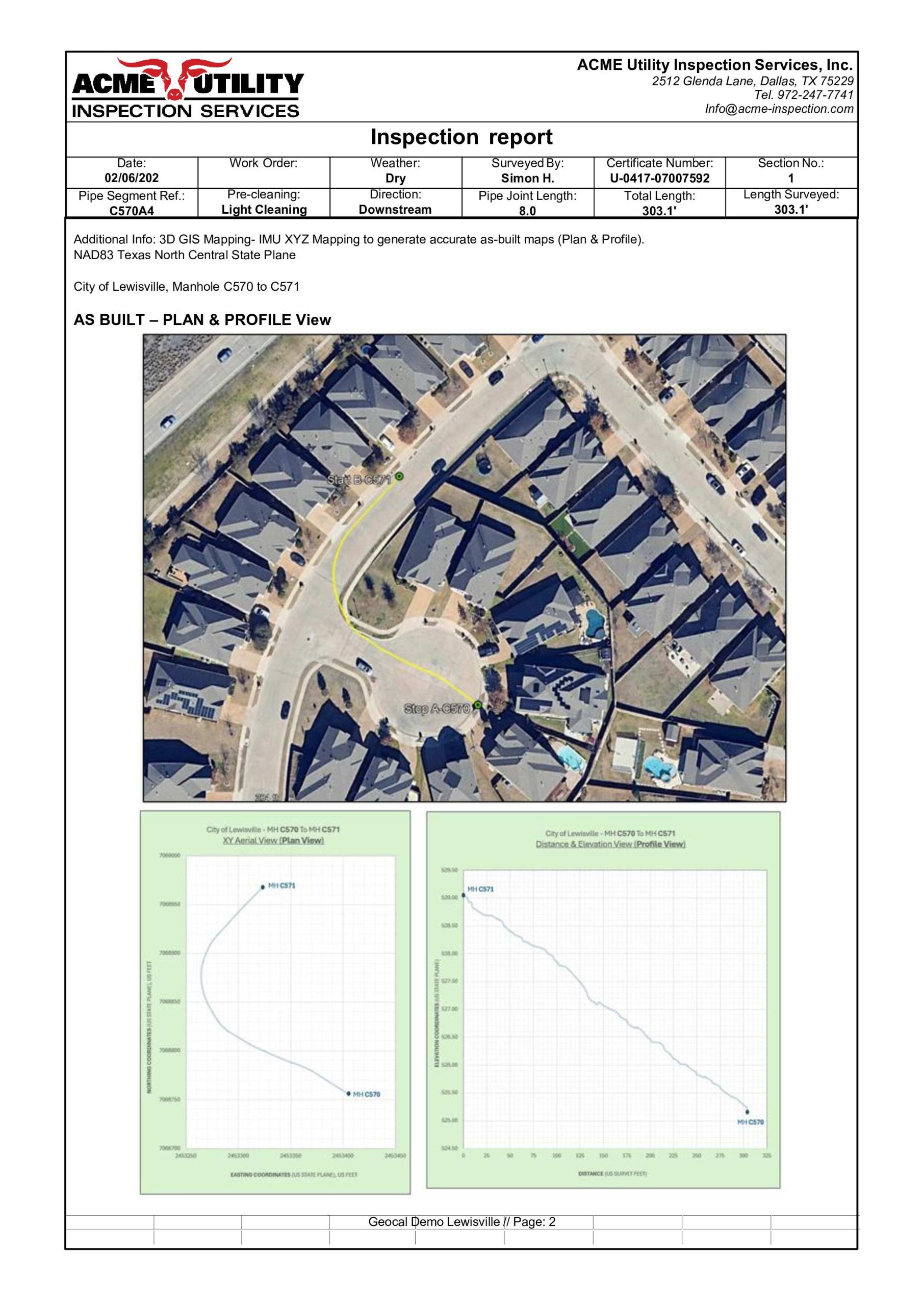
The images in this gallery illustrate how inspection data is transformed into accurate spatial and three-dimensional pipeline records. Visuals highlight alignment, depth, slope, and layout information that supports engineering design, asset management, and long-term documentation. This gallery demonstrates how mapping replaces outdated records with verified underground data that can be relied on for future projects.
Clear Data That Supports Better Decisions
Pipeline 3D mapping provides the clarity needed to plan confidently, reduce risk, and protect infrastructure investments. When accurate underground information matters, mapping delivers value well beyond the initial inspection.
Request Pipeline 3D Mapping to gain reliable insight into your underground assets.


